Seattle Freeway Park Illustrative Site Plan
Anna Renken on an image with many hands
Where the modernist approach to landscape construed the site as a bounded tabula rasa on which the designer could refine a sequenced composition, postmodernism has generally been associated with more complicated understandings of site, process, and use. In the prevalent view of postmodern design, interdisciplinary collaboration aimed to address diverse interests and publics, placing value on both understanding history and accepting things as they are.1 Landscape architecture had, since its formalization as a profession, applied pragmatic and experiential approaches to both social and environmental goals.2 The postmodern opening of the field increased opportunities for inclusion in this process while posing new challenges to communication as conventions and parameters were redefined.
The career of Lawrence Halprin charts this transformation, moving from a modernist foundation into a multivalent practice positioned as contextual, participatory, and intuitive.3 Where his mentors—including Christopher Tunnard and Thomas Church—are recognized for their calibrated gardens and campuses, Halprin is known for his sustained explorations of natural patterns as well as of urban infrastructure.4 Close study of presentation materials produced for Halprin’s professional work exposes the meticulous calculation underlying his widely reproduced gestural sketches. Although these ecological and logistical inquiries can be traced back to early themes of the profession, their presence in a single body of work introduces clashing priorities and techniques—from reverent observation to heavy engineering. Halprin navigated this tension in his 1966 book Freeways, declaring the subject “a new form of urban sculpture for motion,” whose designers should have “great sensitivity not only to structure, but also to the environment.”5 Despite this stated emphasis, references to nature in the text tend to cast “greenery” as peripheral, slide into ecological metaphor, and privilege human experience.6
The dichotomy between expressive interaction with the landscape and its procedural mediation is especially striking in Halprin’s 1976 project Freeway Park. The development of this paradoxical public space was elaborate, both financially and legally, with many actors contributing at each stage. The 1950s plan to cut a twelve-lane segment of Interstate-5 through Seattle—separating the downtown from the upper-class neighbourhood First Hill to the east—proved controversial.7 While protestors marched to “stop the ditch” entirely in 1961, citing pollution and traffic problems, local architects and organizations—including the First Hill Improvement Club and the city’s Arts Commission—promoted covering the freeway with a concrete surface for a park or other development. Regardless, construction of the I-5 was completed without the proposed concrete cover in 19668—the same year Freeways was published. Aware of the book, the City of Seattle invited Halprin to work on the park, and with Angela Danadjieva as design lead, his office began the project in 1969.
By that year, a small public plaza had been built adjacent to the freeway, and a combination of city, state, and federal funding had been secured—some of the land was publicly owned and the space over the freeway could be used without municipal funds, thanks to state-level public air rights.9 Successful negotiations between the city and R.C. Hedreen Company led the private developer to shift a planned twenty-one-story office tower away from the freeway and sink its parking below ground, maintaining space and light for the park while also increasing the property value.10
Acting in response to these circumstances, Halprin’s design has often been characterized as conceptually and spatially connective. The diagonal park forms a lid over the freeway, with the initial Naramore Plaza and Hedreen’s Park Place to the southwest and a new public parking garage beneath the park’s curved northeast segment. Evergreen-lined concrete platforms were built up around three main plazas and a dramatic canyon was carved out for a waterfall.11 This abstract topography addressed the range of stakeholder expectations by producing additional ground and varying its elevation to multiply it even further. By staging views that shift between scales, the irregular aggregation appears organic while maintaining a high level of control. Its discrete, sheltered plots bear closer resemblance to suburban lawns than to an open field.12
-
Postmodernist, The Cultural Landscape Foundation. ↩
-
Charles E. Beveridge, Frederick Law Olmsted Sr., Pioneers of American Landscape Design, eds. Charles A. Birnbaum and Robin Karson (New York City: McGraw-Hill Companies, Inc., 2000), and National Association for Olmsted Parks. ↩
-
Halprin established his office in 1949. Elizabeth K. Meyer, Lawrence Halprin, TCLF. ↩
-
Meyer, Lawrence Halprin. ↩
-
Lawrence Halprin, Freeways (New York City: Reinhold, 1966), 5. ↩
-
Further, awareness of pollution had become widespread by this time, as reflected in publications such as Barry Commoner’s The Closing Circle: Nature, Man, and Technology. Acknowledging the difficulties of communicating environmental problems, Commoner observes a mismatch between conceptual frameworks for technology and nature: “unlike the automobile, the ecosystem cannot be subdivided into manageable parts, for its properties reside in the whole, in the connections between the parts.” With this level of examination present in public discourse, the treatment of natural elements as separable in Freeways is surprising. Barry Commoner, The Closing Circle: Nature, Man, and Technology (New York City: Knopf, 1972), 187. ↩
-
Seattle Neighborhoods—Past, Present, Future, HistoryLink, 4 January 2005. ↩
-
Paul Dorpat and Genevieve McCoy, Building Washington: A History of Washington State Public Works (Seattle, WA: Tartu Publications, 1998), 94–96. ↩
-
Alison B. Hirsch, The Fate of Lawrence Halprin’s Public Spaces: Three Case Studies (master’s thesis, University of Pennsylvania, 2005), 71–75. ↩
-
Ibid., 73. ↩
-
Freeway Park, TCLF. ↩
-
This cellular quality of the park’s design also, however intentionally, limits the potential for large crowds to gather—a fact that seems particularly relevant given the culture of environmental protest at the time, as well as the protests of the freeway extension on the site not long before the park was planned. ↩
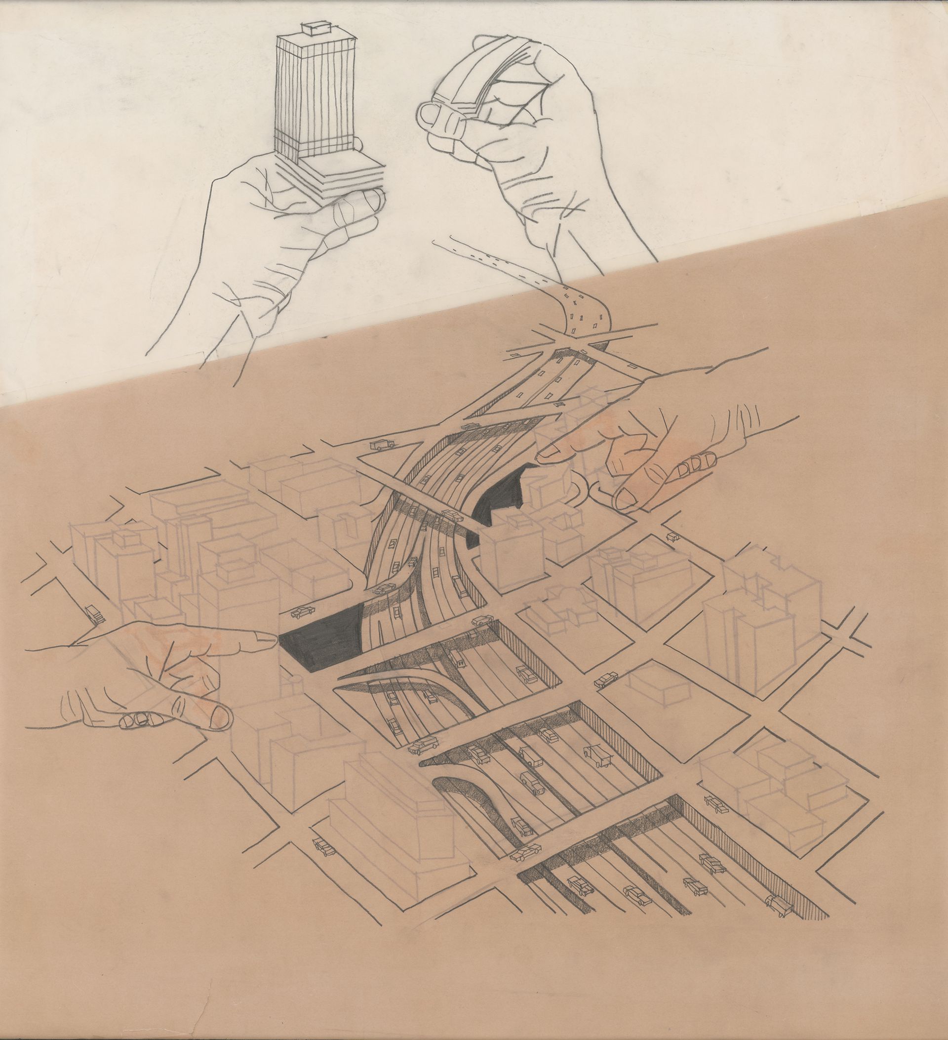
Lawrence Halprin, Seattle Freeway Park illustrative site plan, ca. 1970–1975. White tracing paper with pencil and marker on sepia print, 71.12 × 63.8 cm. 014.II.A.271, The Architectural Archives, University of Pennsylvania, gift of Lawrence Halprin. Image courtesy of The Architectural Archives, University of Pennsylvania.
In an aerial perspective drawing showing the site before the construction of the park, generously spaced cars traverse the curving freeway while two hands point to darkened voids on either side, and two more above hold structures that mark the edges of the future park. These structures are defined with solid lines, but the buildings on the ground have been drawn on the reverse of the tracing paper so they are fainter; the precise yet informal construction of the drawing makes it seem even more telling. The actual park is notably absent from the image, though it could have easily been highlighted with colour, or one hand could have been shown sliding the tower over to make room for another to add greenery. Instead, the drawing implies that the project’s mechanisms can be isolated from the resulting design and situates natural elements as afterthought. The firm’s efforts to simplify the process ultimately reveal its intricacies.
The use of the generic hands betrays a core conflict in the image’s ambition. They fall somewhere between conventions of the heroic hand in photographs of architectural models, the pointing hand in signage, and the repeated hand in instructional diagrams. In such illustrations, the presence of an individual hand usually communicates a basic piece of information, in contrast to the multiple instances and independent actions captured in this case. The four hands could be read as representing different stakeholders—the two pointing hands for the architects and public groups that identified opportunities for the project and the two hands holding the objects for private and state interests in the project—but the aligned and diverging goals at play undermine the clarity of this interpretation. Further, the didactic performance of a kind of exploded perspective—already less legible than an axonometric drawing and removed from the vantage points of both pedestrians and drivers—only adds confusion to the sectionally complex, circulatory site. These graphic tactics, along with the imperfect rendering of the contour lines, make the image seem like a disingenuous attempt to evoke tactile engagement and insist on conceptual accessibility.
A kind of false compromise comes into view through these manoeuvres, suggesting that landscape architecture at the time was operating quite differently than is commonly understood. In a 2003 interview, Halprin described himself as a “general practitioner,” remarking, “I wouldn’t want to be a freeway designer or a specialist in any form of what we do because I think it would be limiting.”1 More than facilitating connection, Freeway Park attested to the discipline’s capacity for managing conflict. The hands are not really working together, nor are they dealing solely with the site’s pre-existing variables. As the four hands act out an adjustment of components to form a new whole, they distract from the project’s main gesture of producing additional, more fragmented territory.2 Rather than reconciling private and public interests with social or environmental agendas, the project extends and rearranges its canvas to serve each separately. In its own way, this strategy might be just as utopian as modernist precedents. Instead of preserving or restoring natural resources, it imagines discovering or replenishing them, or generating them from nothing.
-
Lawrence Halprin, Lawrence Halprin Oral History, interview by Charles A. Birnbaum and Tom Fox, Pioneers of American Landscape Design, TCLF (March 2003, December 2008), 32–33. ↩
-
A related drawing from the archive shows two hands holding a single object that incorporates the plaza, Park Place, public garage, and area between them, as in a traditional site model. Dashed lines connect this object back to the ground, where the park has been indicated by textured surfaces and rows of trees. Lawrence Halprin, Seattle Freeway Park illustrative drawing. 014.II.A.261, The Architectural Archives, University of Pennsylvania School of Design. ↩
This text appears in Architecture Itself and Other Postmodernization Effects.