206 Results
Level of archival description:
Series
Series
Reference number:
AP175.S1
Description:
Series 1, Erasmus Bridge, Rotterdam, Netherlands, 1990-1996, documents the design, conception and construction of a third bridge for Rotterdam over the Nieuwe Maas River. The bridge connects the Kop van Zuid neighborhood, located on the south side of the river, to Willemsplein, located on the north side. The bridge is considered as a landmark in Rotterdam’s landscape. The Erasmus Bridge was a formative project in the thinking of UNStudio. It was originally supposed to be designed by architect Maarten Struijs who was the city of Rotterdam principal architect and who is responsible for the concept of the neighboring Willem Bridge. Ben van Berkel came later into the project and was hired as a designing consultant along with architect Wim Quist. Ben van Berkel proposed design was selected allowing him and his firm, which was called Van Berkel & Bos Architectuurbureau at that time, to supervise the conception and construction of the project, from the original concept to piers design to the selection of every item of bridge furniture such as traffic lights, bridge camera and handrails. The bridge was designed to fit the distinct character and industrial past of Rotterdam. The construction of this landmark was one component of a larger redevelopment project, coinciding with other major developments in the city of Rotterdam. The goal was to develop a dense urban intervention on the southern shore of the Nieuwe Maas, in the Kop van Zuid neighborhood. This explains the implication of UNStudio in the planning of urban configuration of the neighborhoods on both sides of the river and their work for Spido, a ferry company operating on the Nieuwe Maas, work spaces and parking garage. This commercial building was designed by the firm and also hosts The Grand Café and Jazz Café. This commercial building is integrated to one of the bridge pillar on the north shore of the river. For the design the firm used AutoCAD to work along with engineers and to conceptualize 3D models. They also used the software to evaluate the circulation flow of drivers, pedestrians and streetcars, measuring its impact on the structure and the urban configuration of the neighborhoods on both sides of the river. The records contain sketches for bridge and pier design, plans and sections for pier, Spido and bridge, architectural and construction details created by engineering companies for every component of the bridge, from drawbridge, to cable car system, to bridge furnitures such as traffic light, handrails and cameras and photographs documenting the research for precedent and the original configuration of the neighborhoods on both sides of the river. The record contains AutoCAD plans, details and sections for both the bridge and Spido parking garage. The records also contain one physical model: a small scale plastic, glass and metal model of the bridge.
People:
Date:
1990-1996
1990-1996
Title:
Erasmus Bridge, Rotterdam, Netherlands, 1990-1996
Actions:
AP175.S1
Description:
Series 1, Erasmus Bridge, Rotterdam, Netherlands, 1990-1996, documents the design, conception and construction of a third bridge for Rotterdam over the Nieuwe Maas River. The bridge connects the Kop van Zuid neighborhood, located on the south side of the river, to Willemsplein, located on the north side. The bridge is considered as a landmark in Rotterdam’s landscape. The Erasmus Bridge was a formative project in the thinking of UNStudio. It was originally supposed to be designed by architect Maarten Struijs who was the city of Rotterdam principal architect and who is responsible for the concept of the neighboring Willem Bridge. Ben van Berkel came later into the project and was hired as a designing consultant along with architect Wim Quist. Ben van Berkel proposed design was selected allowing him and his firm, which was called Van Berkel & Bos Architectuurbureau at that time, to supervise the conception and construction of the project, from the original concept to piers design to the selection of every item of bridge furniture such as traffic lights, bridge camera and handrails. The bridge was designed to fit the distinct character and industrial past of Rotterdam. The construction of this landmark was one component of a larger redevelopment project, coinciding with other major developments in the city of Rotterdam. The goal was to develop a dense urban intervention on the southern shore of the Nieuwe Maas, in the Kop van Zuid neighborhood. This explains the implication of UNStudio in the planning of urban configuration of the neighborhoods on both sides of the river and their work for Spido, a ferry company operating on the Nieuwe Maas, work spaces and parking garage. This commercial building was designed by the firm and also hosts The Grand Café and Jazz Café. This commercial building is integrated to one of the bridge pillar on the north shore of the river. For the design the firm used AutoCAD to work along with engineers and to conceptualize 3D models. They also used the software to evaluate the circulation flow of drivers, pedestrians and streetcars, measuring its impact on the structure and the urban configuration of the neighborhoods on both sides of the river. The records contain sketches for bridge and pier design, plans and sections for pier, Spido and bridge, architectural and construction details created by engineering companies for every component of the bridge, from drawbridge, to cable car system, to bridge furnitures such as traffic light, handrails and cameras and photographs documenting the research for precedent and the original configuration of the neighborhoods on both sides of the river. The record contains AutoCAD plans, details and sections for both the bridge and Spido parking garage. The records also contain one physical model: a small scale plastic, glass and metal model of the bridge.
Level of archival description:
Series
Series
Date:
1990-1996
1990-1996
People:
Form:
archives
Level of archival description:
Fonds
archives
Level of archival description:
Fonds
Title:
Álvaro Siza fonds
Álvaro Siza fonds
Reference number:
AP178
Description:
The Álvaro Siza fonds documents the architectural work of Portuguese architect Álvaro Siza. Records in this fonds document Siza’s projects from 1958-2012, including built and unbuilt designs. A collaborative project was established between the Canadian Centre for Architecture (CCA), Fundação de Serralves, and Fundação Calouste Gulbenkian to allow for international research and access to the archive. The archive is shared by the three institutions with each institution holding different projects while collaborating on the descriptive work and increasing the visibility of the archive. The holdings at both the Fundação de Serralves and Fundação Calouste Gulbenkian focus on Siza’s Portuguese projects, while the portion of the archive held by the CCA mainly includes Siza’s projects abroad. All three institutions are committed to describing the archive and making it accessible for scholarly research. The processing of the Siza archive held by the CCA has been divided into four phases to allow for access to parts of the archive while still in process. For the first, second, and third phases, the processing archivist has described the projects from the fifties, sixties, and seventies, as well as projects for the IBA competition in Berlin, urban renewal projects in The Hague from the eighties, urban plans, museums, and individual houses between 1980 and 2000. The processing archivist has also described approximately 203 sketchbooks. Many of these sketchbooks include sketches related to architectural projects which were processed. The complete list of projects processed by the CCA to date can be found in series AP178.S1. The bulk of the Álvaro Siza fonds is arranged in Series AP178.S1, which contains documentation for over 200 of Siza’s architectural projects. Records in this archive are predominantly from 1970 to 2000. Series AP178.S1 mainly contains conceptual, design development, presentation, and working drawings. Also included are photographic materials, models, born digital records, and textual documentation, which include correspondence, project proposals, and notes. The architect’s creative process is captured in 282 sketchbooks arranged in Series AP178.S2. In all there are approximately 60 000 drawings, 3000 folders of textual documentation, 9.46 linear meters of photographs and negatives, 6,545 slides, 250 CD-ROMS, 101 floppy disks, and 371 models that document the architectural activities of Siza and his office. Among the drawings are sketches by Siza on various items, such as napkins, receipts, envelopes, or on the back of working drawings. The fonds contains several types of architectural projects including residential buildings, museums, universities, urban plans, offices, and city restorations. Of particular significance are the sketchbooks, comprised of sketches for architectural projects, Siza’s travels, people, and animals as well as notes and draft letters. The sketchbooks are organized in chronological order, starting in the late 1970’s to the beginning of the 2000’s. Locations, notes, and dates have also been identified on the front of each sketchbook along with the sketchbook number. The sketchbooks provide a unique perspective of Siza’s use of drawing as part of his work process.
People:
Date:
1958-2002
1958-2002
Title:
Álvaro Siza fonds
Actions:
AP178
Description:
The Álvaro Siza fonds documents the architectural work of Portuguese architect Álvaro Siza. Records in this fonds document Siza’s projects from 1958-2012, including built and unbuilt designs. A collaborative project was established between the Canadian Centre for Architecture (CCA), Fundação de Serralves, and Fundação Calouste Gulbenkian to allow for international research and access to the archive. The archive is shared by the three institutions with each institution holding different projects while collaborating on the descriptive work and increasing the visibility of the archive. The holdings at both the Fundação de Serralves and Fundação Calouste Gulbenkian focus on Siza’s Portuguese projects, while the portion of the archive held by the CCA mainly includes Siza’s projects abroad. All three institutions are committed to describing the archive and making it accessible for scholarly research. The processing of the Siza archive held by the CCA has been divided into four phases to allow for access to parts of the archive while still in process. For the first, second, and third phases, the processing archivist has described the projects from the fifties, sixties, and seventies, as well as projects for the IBA competition in Berlin, urban renewal projects in The Hague from the eighties, urban plans, museums, and individual houses between 1980 and 2000. The processing archivist has also described approximately 203 sketchbooks. Many of these sketchbooks include sketches related to architectural projects which were processed. The complete list of projects processed by the CCA to date can be found in series AP178.S1. The bulk of the Álvaro Siza fonds is arranged in Series AP178.S1, which contains documentation for over 200 of Siza’s architectural projects. Records in this archive are predominantly from 1970 to 2000. Series AP178.S1 mainly contains conceptual, design development, presentation, and working drawings. Also included are photographic materials, models, born digital records, and textual documentation, which include correspondence, project proposals, and notes. The architect’s creative process is captured in 282 sketchbooks arranged in Series AP178.S2. In all there are approximately 60 000 drawings, 3000 folders of textual documentation, 9.46 linear meters of photographs and negatives, 6,545 slides, 250 CD-ROMS, 101 floppy disks, and 371 models that document the architectural activities of Siza and his office. Among the drawings are sketches by Siza on various items, such as napkins, receipts, envelopes, or on the back of working drawings. The fonds contains several types of architectural projects including residential buildings, museums, universities, urban plans, offices, and city restorations. Of particular significance are the sketchbooks, comprised of sketches for architectural projects, Siza’s travels, people, and animals as well as notes and draft letters. The sketchbooks are organized in chronological order, starting in the late 1970’s to the beginning of the 2000’s. Locations, notes, and dates have also been identified on the front of each sketchbook along with the sketchbook number. The sketchbooks provide a unique perspective of Siza’s use of drawing as part of his work process.
Form:
archives
Level of archival description:
Fonds
archives
Level of archival description:
Fonds
Date:
1958-2002
1958-2002
People:
Form:
exhibitions
exhibitions
Actions:
Description:
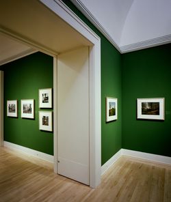
Through a commission from the CCA, three contemporary photographers spent six years interpreting the work of Frederick Law Olmsted (1822–1903), North America’s most important landscape architect. *Viewing Olmsted: Photographs by Robert Burley, Lee Friedlander, and Geoffrey James* presents 155 photographs from this commission to offer visitors an opportunity to understand(...)
Through a commission from the CCA, three contemporary photographers spent six years interpreting the work of Frederick Law Olmsted (1822–1903), North America’s most important landscape architect. *Viewing Olmsted: Photographs by Robert Burley, Lee Friedlander, and Geoffrey James* presents 155 photographs from this commission to offer visitors an opportunity to understand(...)
Location:
Main galleries
Main galleries
Date:
16 October 1996 to 2 February 1997
16 October 1996 to 2 February 1997
Title:
Viewing Olmsted: Photographs by Robert Burley, Lee Friedlander, and Geoffrey James
Actions:
Description:
Through a commission from the CCA, three contemporary photographers spent six years interpreting the work of Frederick Law Olmsted (1822–1903), North America’s most important landscape architect. *Viewing Olmsted: Photographs by Robert Burley, Lee Friedlander, and Geoffrey James* presents 155 photographs from this commission to offer visitors an opportunity to understand(...)
Form:
exhibitions
exhibitions
Date:
16 October 1996 to
2 February 1997
16 October 1996 to
2 February 1997
Location:
Main galleries
Main galleries
Level of archival description:
Project
Project
Reference number:
AP143.S4.D65
Description:
File documents the unexecuted project for the University Art Museum, Long Beach, California. Material in this file was produced between 1986 and 1988. California State University, Long Beach (CSULB), commissioned Eisenman/Robertson Architects to design an art museum adjacent to the main campus entrance. The 67,500-square-foot building was to comprise four galleries, a black-box theater, an auditorium, a cafe, conference rooms, a library, offices, preparation spaces, and storage vaults. The project, sited on a 23-acre arboretum, included landscaping; terraced sculpture courtyards, botanical gardens, and a two-acre pond. Eisenman linked the northern and southern parts of the arboretum by an elevated public walkway through the museum. Sets of drawings were presented on 8 and 30 April, 2 June, and 5 Aug. In the first design phase Eisenman explores the cartographic figures which form the basis of his artificial excavation when superposed: a series of sketches establishes the analogical relationships which fix the relative scales of the plans and produce the superpositions; another series contextualizes the superposed figures by placing them within the museum site (DR1987:0859:087-090). The second phase concerns the building; the working model shows the building carved out of a square pit, from which spring an oil derrick and a reconstruction of a recreational pier (Rainbow Pier, 1920s) used here as circulatory bridge (DR1987:0859:160). In the third phase the architect systematizes his archeological procedure by using five significant cartographic dates - 1849, 1889, 1949, 1989, 2049 - each corresponding to a specific superposition (see DR1987:0859:274-277). In the fourth phase, Eisenman simplifies the superposition of 2049 to a few iconic colour-coded forms: ranch (green), ranch house (blue), campus site (red), and water forms (river and pond) (gold). Material for the fourth phase includes three relief models, four presentation drawings, and a model (property of the CSULB) (relief models: DR1987:0859:001-003; drawings: DR1987:0859:004-008). Eisenman "inhabits" his artifical archeology by detailed planning of interior spaces, and gives substance to the cartographic traces in a series of sketch sections, perspectives, and working models. Working models reveal how the central "canal" area gradually became the museum's access point (DR1987:0859:484-490); the museum, galleries, offices, and preparation areas are on one side of this deep cut, while the cafeteria and black-box theater are on the other. The upper level was to house offices, meeting rooms, and the library. File contains audiovisual material, conceptual drawings, design development drawings, presentation drawings, reference drawings, working drawings, photographic materials, and textual records.
People:
Date:
1986-1988
1986-1988
Title:
University Art Museum
Actions:
AP143.S4.D65
Description:
File documents the unexecuted project for the University Art Museum, Long Beach, California. Material in this file was produced between 1986 and 1988. California State University, Long Beach (CSULB), commissioned Eisenman/Robertson Architects to design an art museum adjacent to the main campus entrance. The 67,500-square-foot building was to comprise four galleries, a black-box theater, an auditorium, a cafe, conference rooms, a library, offices, preparation spaces, and storage vaults. The project, sited on a 23-acre arboretum, included landscaping; terraced sculpture courtyards, botanical gardens, and a two-acre pond. Eisenman linked the northern and southern parts of the arboretum by an elevated public walkway through the museum. Sets of drawings were presented on 8 and 30 April, 2 June, and 5 Aug. In the first design phase Eisenman explores the cartographic figures which form the basis of his artificial excavation when superposed: a series of sketches establishes the analogical relationships which fix the relative scales of the plans and produce the superpositions; another series contextualizes the superposed figures by placing them within the museum site (DR1987:0859:087-090). The second phase concerns the building; the working model shows the building carved out of a square pit, from which spring an oil derrick and a reconstruction of a recreational pier (Rainbow Pier, 1920s) used here as circulatory bridge (DR1987:0859:160). In the third phase the architect systematizes his archeological procedure by using five significant cartographic dates - 1849, 1889, 1949, 1989, 2049 - each corresponding to a specific superposition (see DR1987:0859:274-277). In the fourth phase, Eisenman simplifies the superposition of 2049 to a few iconic colour-coded forms: ranch (green), ranch house (blue), campus site (red), and water forms (river and pond) (gold). Material for the fourth phase includes three relief models, four presentation drawings, and a model (property of the CSULB) (relief models: DR1987:0859:001-003; drawings: DR1987:0859:004-008). Eisenman "inhabits" his artifical archeology by detailed planning of interior spaces, and gives substance to the cartographic traces in a series of sketch sections, perspectives, and working models. Working models reveal how the central "canal" area gradually became the museum's access point (DR1987:0859:484-490); the museum, galleries, offices, and preparation areas are on one side of this deep cut, while the cafeteria and black-box theater are on the other. The upper level was to house offices, meeting rooms, and the library. File contains audiovisual material, conceptual drawings, design development drawings, presentation drawings, reference drawings, working drawings, photographic materials, and textual records.
Level of archival description:
File 65
File 65
Date:
1986-1988
1986-1988
People:
Form:
archives
Level of archival description:
Fonds
archives
Level of archival description:
Fonds
Title:
Milton Parc fonds
Milton Parc fonds
Actions:
Reference number:
AP025
Synopsis:
The Milton Parc fonds, 1969 – 1989, documents the Société du patrimoine urbaine de Montréal’s (SPUM) planning, design and renovation of Montreal’s historic Milton Parc neighbourhood. Recognized as one of the largest co-operative rehabilitation projects completed in Canada, the Milton Parc housing project (1979-1982) renovated over 135 historic buildings and 597 dwelling units within Milton Parc’s 6-block radius. The fonds consists of the following materials: approximately 600 drawings, 85 l.m. of textual records, 0.6 l.m. of slides, 0.6 l.m.of photographs, 8 posters, 3 seals, 2 models, 2 rubber stamps, and 2 audio cassettes.
People:
Date:
1962-1989
1962-1989
Title:
Milton Parc fonds
Actions:
AP025
Synopsis:
The Milton Parc fonds, 1969 – 1989, documents the Société du patrimoine urbaine de Montréal’s (SPUM) planning, design and renovation of Montreal’s historic Milton Parc neighbourhood. Recognized as one of the largest co-operative rehabilitation projects completed in Canada, the Milton Parc housing project (1979-1982) renovated over 135 historic buildings and 597 dwelling units within Milton Parc’s 6-block radius. The fonds consists of the following materials: approximately 600 drawings, 85 l.m. of textual records, 0.6 l.m. of slides, 0.6 l.m.of photographs, 8 posters, 3 seals, 2 models, 2 rubber stamps, and 2 audio cassettes.
Form:
archives
Level of archival description:
Fonds
archives
Level of archival description:
Fonds
Date:
1962-1989
1962-1989
People:
Form:
books
books
Title:
California mission landscapes : race, memory, and the politics of heritage / Elizabeth Kryder-Reid.
California mission landscapes : race, memory, and the politics of heritage / Elizabeth Kryder-Reid.
Actions:
Holdings:
Description:
xv, 355 pages : illustrations ; 26 cm.
Description:
xv, 355 pages : illustrations ; 26 cm.
Author:
Subject:
Publication:
Minneapolis : University of Minnesota Press, [2016]
Minneapolis : University of Minnesota Press, [2016]
Title:
California mission landscapes : race, memory, and the politics of heritage / Elizabeth Kryder-Reid.
Actions:
Holdings:
Description:
xv, 355 pages : illustrations ; 26 cm.
California mission landscapes : race, memory, and the politics of heritage / Elizabeth Kryder-Reid.
Actions:
Holdings:
Description:
xv, 355 pages : illustrations ; 26 cm.
Form:
books
books
Publication:
Minneapolis : University of Minnesota Press, [2016]
Minneapolis : University of Minnesota Press, [2016]
Author:
Subject:
Form:
books
books
Actions:
Holdings:
Description:
ix, 309 pages : illustrations ; 27 cm
Description:
ix, 309 pages : illustrations ; 27 cm
Author:
Subject:
Publication:
Albuquerque : University of New Mexico Press, [2001], ©2001
Albuquerque : University of New Mexico Press, [2001], ©2001
Title:
View finder : Mark Klett, photography, and the reinvention of landscape / William L. Fox.
Actions:
Holdings:
Description:
ix, 309 pages : illustrations ; 27 cm
View finder : Mark Klett, photography, and the reinvention of landscape / William L. Fox.
Actions:
Holdings:
Description:
ix, 309 pages : illustrations ; 27 cm
Form:
books
books
Publication:
Albuquerque : University of New Mexico Press, [2001], ©2001
Albuquerque : University of New Mexico Press, [2001], ©2001
Author:
Subject:
Form:
books
books
Actions:
Holdings:
Description:
323 pages : illustrations (some color) ; 29 cm
Description:
323 pages : illustrations (some color) ; 29 cm
Author:
Subject:
Publication:
Chicago : University of Chicago Press, ©1993.
Chicago : University of Chicago Press, ©1993.
Title:
Albrecht Altdorfer and the origins of landscape / Christopher S. Wood.
Actions:
Holdings:
Description:
323 pages : illustrations (some color) ; 29 cm
Albrecht Altdorfer and the origins of landscape / Christopher S. Wood.
Actions:
Holdings:
Description:
323 pages : illustrations (some color) ; 29 cm
Form:
books
books
Publication:
Chicago : University of Chicago Press, ©1993.
Chicago : University of Chicago Press, ©1993.
Author:
Subject:
Form:
books
books
Actions:
Holdings:
Description:
3 volumes : illustrations en couleur ; 26 cm
Description:
3 volumes : illustrations en couleur ; 26 cm
Author:
Subject:
Publication:
Pittsburgh, Pennsylvania : Carnegie Museum of Art, [2021]
Pittsburgh, Pennsylvania : Carnegie Museum of Art, [2021]
Title:
The fabricated landscape / edited by Raymund Ryan.
Actions:
Holdings:
Description:
3 volumes : illustrations en couleur ; 26 cm
The fabricated landscape / edited by Raymund Ryan.
Actions:
Holdings:
Description:
3 volumes : illustrations en couleur ; 26 cm
Form:
books
books
Publication:
Pittsburgh, Pennsylvania : Carnegie Museum of Art, [2021]
Pittsburgh, Pennsylvania : Carnegie Museum of Art, [2021]
Author:
Subject:
Form:
books
books
Holdings:
Description:
294 pages : illustrations (some color), plans, facsimiles ; 20 cm
Description:
294 pages : illustrations (some color), plans, facsimiles ; 20 cm
Author:
Subject:
Publication:
Barcelona : Actar, 2003.
Barcelona : Actar, 2003.
Title:
Re-envisioning landscape/architecture / Catherine Spellman, ed.
Actions:
Holdings:
Description:
294 pages : illustrations (some color), plans, facsimiles ; 20 cm
Re-envisioning landscape/architecture / Catherine Spellman, ed.
Actions:
Holdings:
Description:
294 pages : illustrations (some color), plans, facsimiles ; 20 cm
Form:
books
books
Publication:
Barcelona : Actar, 2003.
Barcelona : Actar, 2003.
Author:
Subject: